
CAMPING IN KARNATAKA

"Hail ! the beloved daughter of the Mother India;
Hail ! the Motherland Karnataka!
Hail ! the land of beautiful mountains and forests,
Hail ! thy abode of gifted saints and poets! "
This Kannada poem by greatest Kannada poet K.V.Puttappa (Kuvempu - Pen Name) gives the best description of Karnataka. The name of the land Karnataka has come from `Kari-nadu`meaning the land of black soil, & some others hold that `Karunadu` also means beautiful country; either way the land is celebrated as beautiful throughout its ancient literature. Karnataka is the eighth largest state in India in both area and population. It was formerly known as Mysore. On November 1,1973, the name Mysore was changed to Karnataka. It is situated on the western edge of the Deccan plateau and is surrounded by Maharashtra and Goa on the north, Andhra Pradesh on the east, and Tamil Nadu and Kerala on the south. On the west, it opens out on the Arabian Sea. It has an area of around 192,000 km² and the population of the state is over 55,868,200. Kannada is the official language of the state. The major rivers the Cauvery, the Krishna and the Godavari flow through the state with their tributaries.
Karnataka with all its Richness in Culture and Traditional Grandeur is also one of the fastest growing States in terms of Industries and Facilities. Karnataka is also known as the Capital of Agarbathi (Incense Sticks), Arecanut, Silk, Coffee and Sandal Wood. It is the nature's kaleidoscope at its best with lush green forests, cool blue seas, sparkling white waterfalls, seemingly endless plains and sky touching hills.
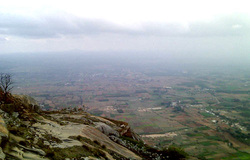
Trekking is considered one of the best ways to exploits the scenic beauty of any place. And, if trekking is a sport you like, then Karnataka can be easily considered as one of the best destinations for the same. The demographic location is such that it offers several picturesque mountains that are quite famous and popular among trekkers, not just for the adventure but also the scenic beauty and the serenity that it offers. There are more than 200 trails available in Karnataka, but the below mentioned are some of the most popular ones among trekkers.
Hail ! the Motherland Karnataka!
Hail ! the land of beautiful mountains and forests,
Hail ! thy abode of gifted saints and poets! "
This Kannada poem by greatest Kannada poet K.V.Puttappa (Kuvempu - Pen Name) gives the best description of Karnataka. The name of the land Karnataka has come from `Kari-nadu`meaning the land of black soil, & some others hold that `Karunadu` also means beautiful country; either way the land is celebrated as beautiful throughout its ancient literature. Karnataka is the eighth largest state in India in both area and population. It was formerly known as Mysore. On November 1,1973, the name Mysore was changed to Karnataka. It is situated on the western edge of the Deccan plateau and is surrounded by Maharashtra and Goa on the north, Andhra Pradesh on the east, and Tamil Nadu and Kerala on the south. On the west, it opens out on the Arabian Sea. It has an area of around 192,000 km² and the population of the state is over 55,868,200. Kannada is the official language of the state. The major rivers the Cauvery, the Krishna and the Godavari flow through the state with their tributaries.
Karnataka with all its Richness in Culture and Traditional Grandeur is also one of the fastest growing States in terms of Industries and Facilities. Karnataka is also known as the Capital of Agarbathi (Incense Sticks), Arecanut, Silk, Coffee and Sandal Wood. It is the nature's kaleidoscope at its best with lush green forests, cool blue seas, sparkling white waterfalls, seemingly endless plains and sky touching hills.
Trekking is considered one of the best ways to exploits the scenic beauty of any place. And, if trekking is a sport you like, then Karnataka can be easily considered as one of the best destinations for the same. The demographic location is such that it offers several picturesque mountains that are quite famous and popular among trekkers, not just for the adventure but also the scenic beauty and the serenity that it offers. There are more than 200 trails available in Karnataka, but the below mentioned are some of the most popular ones among trekkers.
BEST TO CAM HERE
The Prominent Among The Camps Run Are :
1. Kumara Parvata
2. Agumbe
3. Kudremukh
4. Kurinjal
5. Kodachadri
6. Edakumeri
7. Tadiyandamol
8. Siddara Betta
9. Bananthimari Betta
10. Kalavarahalli Beta
The Prominent Among The Camps Run Are :
1. Kumara Parvata
2. Agumbe
3. Kudremukh
4. Kurinjal
5. Kodachadri
6. Edakumeri
7. Tadiyandamol
8. Siddara Betta
9. Bananthimari Betta
10. Kalavarahalli Beta
KUMARA PARVATA
Popular among the trekkers of Bangalore, it is considered as a trekker’s paradise in spite of the treacherous journey involved. The journey, they say, is worth every difficulty faced because the end result on reaching the peak is that of witnessing unspeakable beauty and calmness that surrounds this place. The peak is at a height of 1712m and the best way to start the journey to Kumara Parvata is to first reach Subramanya which is about 230kms from Bangalore. It’s a small town mostly famous among the Hindu for their snake deity and its temple, Kukke Subramanya temple. The trek starts from Subramanya from where the peak is at a distance of 15+kms. Dense greenery will give way to a little flatter pathway and you will also find accommodation at Bhattara Mane. From here, you again get lost amongst the lush vegetation before finally reaching the peak. Apart from the peak, the Kukke Subramanya temple and Pushpagiri wildlife sanctuary make up the other attractions available to the trekkers.
Popular among the trekkers of Bangalore, it is considered as a trekker’s paradise in spite of the treacherous journey involved. The journey, they say, is worth every difficulty faced because the end result on reaching the peak is that of witnessing unspeakable beauty and calmness that surrounds this place. The peak is at a height of 1712m and the best way to start the journey to Kumara Parvata is to first reach Subramanya which is about 230kms from Bangalore. It’s a small town mostly famous among the Hindu for their snake deity and its temple, Kukke Subramanya temple. The trek starts from Subramanya from where the peak is at a distance of 15+kms. Dense greenery will give way to a little flatter pathway and you will also find accommodation at Bhattara Mane. From here, you again get lost amongst the lush vegetation before finally reaching the peak. Apart from the peak, the Kukke Subramanya temple and Pushpagiri wildlife sanctuary make up the other attractions available to the trekkers.
AGUMBE
Aptly known as “Chirapunji of the south”, Agumbe is another one of trekker’s favorite places. As the title suggests, it gets heavy rainfall ensuring that the flora and the fauna are diverse making it a hotspot not only for the trekkers looking for adventure but also to nature lovers and photograph enthusiasts. From Bangalore, Agumbe is at a distance of about 380kms via Tumkur- Shimoga to Thirthahalli. By train, via konkan railway to Udupi will be the closest and by air, via Mangalore. From Mangalore there are several buses which will lead you to Agumbe. Make sure you pack a good camera for the journey as you are sure to find a lot of different species of animals and birds in their natural habitat in Agumbe. It hosts two wildlife parks, one Someshwara Wildlife sanctuary and another Kudremukh National Park. You can also be a witness, on a clear day, to the sun setting on the Arabian Sea at Sunset point. The popularity of this place is evident by the number of visitors who throng this place for the view.
There are several waterfalls, adding to the reasons why one should visit Agumbe. There is Kunchikal Falls formed by Varahi River, which is the second highest waterfalls recorded in India and ranking 116th in world with a height of 455mts. There is Barkana falls at the height of 850 mts formed by the Seeta River making it the 10th highest in the country. Local’s favorite picnic spots form the Onake Abbi falls and Jogigundi falls, both close to Agumbe. And if all this doesn’t satisfy your thirst for adventure and travel, there is the Gopalakrishna temple which stands for the architectural splendor of the Hoysala period, built during the 14th century. This only adds to the beauty of what is, Agumbe.
KUDREMUKH
If you are familiar with Kannada, the state language of Karnataka then you will understand why the place has been named so. Kudremukh, in translation means, horse face and it is very apt as one side of the mountain resembles the face of a horse. This place is very famous due to the presence of KIOCL, which is a government run Iron ore Mining Company. Situated in Chikmangalur district you can start the trek from Samse which is a few kilometers away from the peak. From there you will reach lobo mane, from where reaching the peak will be, on an average, 3 to 4 hours pathway. Another popular route taken by trekkers is from Kaikamba which is a place situated between Belthangady and Navoor. Though the start point is different it meets the same lobo mane and then the route is similar to the first route mentioned above. Camping here however, could be tricky, as the peak is situated inside the Kudremukh National Park and is guarded by several rules and regulations by the authorities in order to protect the flora and fauna present in the place. As mentioned earlier Kudremukh is not just popular for the beauty of the peak but also due to the diverse wildlife one gets to see. Add to that, an old abandoned church that one can see from below the summit which is about half and hour distance from the same. There is also Hanuman Gundi which is at a distance of about 32 km from Kalasa, which is close to Kudremukh. Getting there will involve a test of your trekking skills as the place is very slippery however on reaching there you will be overwhelmed by the beauty of the falls which is at a height of about 100 ft. If scenic beauty along with the lushness of the forest is what you seek, then a trek to Kudremukh is what you should plan.
If you are familiar with Kannada, the state language of Karnataka then you will understand why the place has been named so. Kudremukh, in translation means, horse face and it is very apt as one side of the mountain resembles the face of a horse. This place is very famous due to the presence of KIOCL, which is a government run Iron ore Mining Company. Situated in Chikmangalur district you can start the trek from Samse which is a few kilometers away from the peak. From there you will reach lobo mane, from where reaching the peak will be, on an average, 3 to 4 hours pathway. Another popular route taken by trekkers is from Kaikamba which is a place situated between Belthangady and Navoor. Though the start point is different it meets the same lobo mane and then the route is similar to the first route mentioned above. Camping here however, could be tricky, as the peak is situated inside the Kudremukh National Park and is guarded by several rules and regulations by the authorities in order to protect the flora and fauna present in the place. As mentioned earlier Kudremukh is not just popular for the beauty of the peak but also due to the diverse wildlife one gets to see. Add to that, an old abandoned church that one can see from below the summit which is about half and hour distance from the same. There is also Hanuman Gundi which is at a distance of about 32 km from Kalasa, which is close to Kudremukh. Getting there will involve a test of your trekking skills as the place is very slippery however on reaching there you will be overwhelmed by the beauty of the falls which is at a height of about 100 ft. If scenic beauty along with the lushness of the forest is what you seek, then a trek to Kudremukh is what you should plan.
KURINJAL
If you can manage two places in one trek then very close to Kudremukh is Kurinjal. This place is at a distance of 20 km from main Kudremukh Colony. There are mainly two routes. First one is after the Bhagavathi forest check post whilst the other is from a small village called a Mala. Once you scale the Gangadikal peak, you get to see the Kudremukh peaks and also somewhere between might spot the backwaters of Lankya Dam making the trip from Kudremukh to here a two in one treat. Set in Western Ghats, there is dense vegetation and forests and if fortunate, may spot a bison or two strolling in their natural habitat. Along the trek you will also find an old abandoned receiver station. If you long for a long but adventurous vacation then make sure to head to Kurinjal after Kudremukh.
If you can manage two places in one trek then very close to Kudremukh is Kurinjal. This place is at a distance of 20 km from main Kudremukh Colony. There are mainly two routes. First one is after the Bhagavathi forest check post whilst the other is from a small village called a Mala. Once you scale the Gangadikal peak, you get to see the Kudremukh peaks and also somewhere between might spot the backwaters of Lankya Dam making the trip from Kudremukh to here a two in one treat. Set in Western Ghats, there is dense vegetation and forests and if fortunate, may spot a bison or two strolling in their natural habitat. Along the trek you will also find an old abandoned receiver station. If you long for a long but adventurous vacation then make sure to head to Kurinjal after Kudremukh.
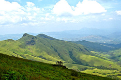
KODACHARI
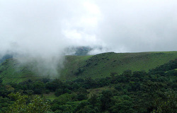
Set at an altitude of about 1343mts above sea level, Kodachadri is simply a must on every trekkers list. Situated in Shimoga District of Karnataka, the peak is most popular due to the golden glow that the Arabian Sea gets as the sun sets in. It is the same peak which is sanctified by Adishankaracharya, who is said to have meditated here and as a witness to it, is the “Sarvajna peetha”. To reach this peak you have to first reach Shimoga which is at a distance of about 285 km from Bangalore. From there, public transport is easily available to Nagodi village from where the trek actually starts. Another route is from Kollur which reaches Nagara in Shimoga after 45 minutes of travel. Here, you will not just find trekkers looking for a thrill, but also will find a lot of devotees travelling towards the famous Mookambika Temple which is situated in Kodachadri. There are also several waterfalls located in and around Kodachadri. For the more adventurous ones there is Hidlumane, a waterfall which is at a distance of about 10 kms from Kodachadri. Closer to Kollur, there is Arasinagundi falls and a little further at Jadkal is the Belakallu theertha falls. Adding to the list of reasons to visit Kodachadri is the presence of an old fort, around 25 kms from Kodachadri, which was built around 18th century called the Nagara Fort. The backwaters of the Linganamakki dam on Saravathi River makes the background giving it a rustic feel. The constant amount of travellers visiting this place ensures good supply of transportation, accommodation as well as food. This makes it a great place to trek especially for amateur trekkers.
Set at an altitude of about 1343mts above sea level, Kodachadri is simply a must on every trekkers list. Situated in Shimoga District of Karnataka, the peak is most popular due to the golden glow that the Arabian Sea gets as the sun sets in. It is the same peak which is sanctified by Adishankaracharya, who is said to have meditated here and as a witness to it, is the “Sarvajna peetha”. To reach this peak you have to first reach Shimoga which is at a distance of about 285 km from Bangalore. From there, public transport is easily available to Nagodi village from where the trek actually starts. Another route is from Kollur which reaches Nagara in Shimoga after 45 minutes of travel. Here, you will not just find trekkers looking for a thrill, but also will find a lot of devotees travelling towards the famous Mookambika Temple which is situated in Kodachadri. There are also several waterfalls located in and around Kodachadri. For the more adventurous ones there is Hidlumane, a waterfall which is at a distance of about 10 kms from Kodachadri. Closer to Kollur, there is Arasinagundi falls and a little further at Jadkal is the Belakallu theertha falls. Adding to the list of reasons to visit Kodachadri is the presence of an old fort, around 25 kms from Kodachadri, which was built around 18th century called the Nagara Fort. The backwaters of the Linganamakki dam on Saravathi River makes the background giving it a rustic feel. The constant amount of travellers visiting this place ensures good supply of transportation, accommodation as well as food. This makes it a great place to trek especially for amateur trekkers.

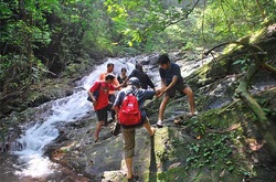
EDAKUMERI
If a different kind of trek is what you want then a visit to Edakumeri is what is ordered. The reason this trek is different is because this stretch of trek path lies along the railway track starting from Sakaleshpur to Kukke Subramanya road station. The dense forest all along the journey gives this place its name Green Route. The stretch of the track is at about 52+kms with more than 50 odd tunnels and bridges, which you will encounter on your journey. The whole journey is very satisfying with abundance of greenery and lushness which is a treat to sore eyes. Though your trek begins from Donigal which is at a distance of about 8kms from Sakaleshpur, the destinations are several. You can end your journey at Yedukameri which is approximately 17kms or Shirabhagilu which is approximately at a distance of 25 kms or Gundya. However among trekkers the route between Donigal to Yedukameri is very popular. You will get to see several tunnels and bridges along the way which may vary from few metes to 0.75kms in length and height varying from few metes to 200+metes. The entire stretch is captivating with the little streams and rivulets that you will keep seeing on the journey. This journey will certainly require more homework before the trek begins. It’s best to take note of all train timings in order to avoid the train passing while crossing the bridge. It is also advised to have someone who is well versed with the area along with you on the trek and also beware of elephants as this is their natural territory and are the most encountered on this stretch. So if it is adventure of different nature you want then, Edakumeri is the place you want to go.
If a different kind of trek is what you want then a visit to Edakumeri is what is ordered. The reason this trek is different is because this stretch of trek path lies along the railway track starting from Sakaleshpur to Kukke Subramanya road station. The dense forest all along the journey gives this place its name Green Route. The stretch of the track is at about 52+kms with more than 50 odd tunnels and bridges, which you will encounter on your journey. The whole journey is very satisfying with abundance of greenery and lushness which is a treat to sore eyes. Though your trek begins from Donigal which is at a distance of about 8kms from Sakaleshpur, the destinations are several. You can end your journey at Yedukameri which is approximately 17kms or Shirabhagilu which is approximately at a distance of 25 kms or Gundya. However among trekkers the route between Donigal to Yedukameri is very popular. You will get to see several tunnels and bridges along the way which may vary from few metes to 0.75kms in length and height varying from few metes to 200+metes. The entire stretch is captivating with the little streams and rivulets that you will keep seeing on the journey. This journey will certainly require more homework before the trek begins. It’s best to take note of all train timings in order to avoid the train passing while crossing the bridge. It is also advised to have someone who is well versed with the area along with you on the trek and also beware of elephants as this is their natural territory and are the most encountered on this stretch. So if it is adventure of different nature you want then, Edakumeri is the place you want to go.
TADIYANMOL
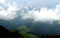
Coorg is place well known for the scenic beauty it represents. People who known Coorg will describe it as a place where heaven meets the earth. Tadiyandamol literally means highest point in Kodava language and it is the highest point in all of Kodagu. From Bangalore, Tadiyandamol is at a distance of 250+kms. Virajpete which is 30kms away from the peak is the next destination from where the trek begins. On the way towards the peak you will come across an old palace popularly known as ‘Nalku Naadu Aramane’. The peak is at around 6kms from the stop called Aramane stop from Virajpete side. The best time to go to this place is early winter when the entire place is almost engulfed in clouds. The mountains streams and small fountains make for pleasing sight. Usually a one day trek, other places of interest is Bhagmandal, Abbey falls and Nagara Hole all close to Coorg.
Coorg is place well known for the scenic beauty it represents. People who known Coorg will describe it as a place where heaven meets the earth. Tadiyandamol literally means highest point in Kodava language and it is the highest point in all of Kodagu. From Bangalore, Tadiyandamol is at a distance of 250+kms. Virajpete which is 30kms away from the peak is the next destination from where the trek begins. On the way towards the peak you will come across an old palace popularly known as ‘Nalku Naadu Aramane’. The peak is at around 6kms from the stop called Aramane stop from Virajpete side. The best time to go to this place is early winter when the entire place is almost engulfed in clouds. The mountains streams and small fountains make for pleasing sight. Usually a one day trek, other places of interest is Bhagmandal, Abbey falls and Nagara Hole all close to Coorg.
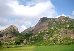
SIDDARA-BETTA
If cave exploration is your thing, then Siddara Betta is the best place to visit. Situated in Koratagere of Tumkur, Siddara Betta is at a distance of about 97kms from Bangalore and at a height of 3660ft above sea level. The trek path is about 12kms to the peak from Koratagere. This place is famous not only for the pathway that is meant for trekking but is also famous for pilgrimage. The cave temple in dedication to Siddeshwara can be found here which ensures a steady set of pilgrims on pilgrimage to this place. The cave is said to have housed several hermits and saints who used to meditate here and so the name Siddara Betta is derived. The surrounding has several herbs and medicinal shrubs growing which made it a treasure trove for people who were on the look out for medicaments. The fountain that flows is also considered to have medicinal value. If you enjoy the pleasure of seeing birds then Siddara Betta won’t disappoint you. It is considered as a natural habitat of yellow throated Bulbul. It’s a whole package deal with cave exploration bird watching and trekking all rolled into one.
If cave exploration is your thing, then Siddara Betta is the best place to visit. Situated in Koratagere of Tumkur, Siddara Betta is at a distance of about 97kms from Bangalore and at a height of 3660ft above sea level. The trek path is about 12kms to the peak from Koratagere. This place is famous not only for the pathway that is meant for trekking but is also famous for pilgrimage. The cave temple in dedication to Siddeshwara can be found here which ensures a steady set of pilgrims on pilgrimage to this place. The cave is said to have housed several hermits and saints who used to meditate here and so the name Siddara Betta is derived. The surrounding has several herbs and medicinal shrubs growing which made it a treasure trove for people who were on the look out for medicaments. The fountain that flows is also considered to have medicinal value. If you enjoy the pleasure of seeing birds then Siddara Betta won’t disappoint you. It is considered as a natural habitat of yellow throated Bulbul. It’s a whole package deal with cave exploration bird watching and trekking all rolled into one.
BANANTHIMARI-BETTA
At a distance of 75kms from Bangalore is a hideout of sorts called Bananthimari Betta, a hideout because it’s less frequented but nothing short on beauty. It derives its name from a temple of Bananthimari which is located at the base of the peak. Bananthimari means a mother nursing a baby. Snuggled between Konanadoddi and Kunthnahalli Bananthimari Betta offers beautiful green valley with a stream flowing bountifully. The trek path is simple. It’s just at a distance of 3kms from Kanakapura on the Kanakapura and Ramanagaram road. You have to reach the temple at the base and from thereon trek up to the peak. From the peak you get a stunning view of all the hills surrounding Bananthimari like the Ramadevara Betta, Kabbaldurga and Savandurgs. So a quite place for trekking is what you want then Bananthimari Betta is the best place to visit.
At a distance of 75kms from Bangalore is a hideout of sorts called Bananthimari Betta, a hideout because it’s less frequented but nothing short on beauty. It derives its name from a temple of Bananthimari which is located at the base of the peak. Bananthimari means a mother nursing a baby. Snuggled between Konanadoddi and Kunthnahalli Bananthimari Betta offers beautiful green valley with a stream flowing bountifully. The trek path is simple. It’s just at a distance of 3kms from Kanakapura on the Kanakapura and Ramanagaram road. You have to reach the temple at the base and from thereon trek up to the peak. From the peak you get a stunning view of all the hills surrounding Bananthimari like the Ramadevara Betta, Kabbaldurga and Savandurgs. So a quite place for trekking is what you want then Bananthimari Betta is the best place to visit.
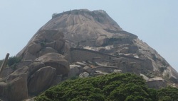
KALAVARAHALLI-BETTA
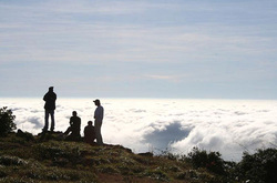
Nearly 70kms from Bangalore, located off the road from Bellary is the Kalavarahalli Betta. It is set at an altitude of about 1350mts and is very close to Nandi hills and Chikkaballapura.It gets its name from the village of Kalavarahalli where it is located. This place is very popular among trekkers as this peak allows night trek which allows the trekkers to witness the glorious sunrise which is an experience in it self. The other main attractions in this place are the fort of Tippu Sultan, which still exists to this day. There is also existence of two caves which is very popular as at the end of the cave is a temple very popular among the locals. One of the caves start at the base and ends at the top where the temple is located, whereas the other is just 30 feet from the midway of the trek. Rightfully considered a haven with the peak being above the clouds, it grows on you, leaving a permanent prominent memory forever in your mind.
Nearly 70kms from Bangalore, located off the road from Bellary is the Kalavarahalli Betta. It is set at an altitude of about 1350mts and is very close to Nandi hills and Chikkaballapura.It gets its name from the village of Kalavarahalli where it is located. This place is very popular among trekkers as this peak allows night trek which allows the trekkers to witness the glorious sunrise which is an experience in it self. The other main attractions in this place are the fort of Tippu Sultan, which still exists to this day. There is also existence of two caves which is very popular as at the end of the cave is a temple very popular among the locals. One of the caves start at the base and ends at the top where the temple is located, whereas the other is just 30 feet from the midway of the trek. Rightfully considered a haven with the peak being above the clouds, it grows on you, leaving a permanent prominent memory forever in your mind.
